|
|
|
|
|
|
| Use Side Menu |
|
|
|
| Some functions can be enabled / disabled using the side menu on the top right of the screen. |
|
|
|

|
|
Satellite |
[Initial status: enabled] |
|
|

|
|
Camera control panel |
|
|

|
|
Grid |
|
|

|
|
Hide menu |
|
|

|
|
View point |
|
|

|
|
Calender Timer |
|
|

|
|
Height bar |
|
|

|
|
Target Data |
|
|
|
|
|
|
|
| Satellite |
|
|
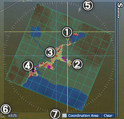
Show miniature 2D diagram of the whole map.
①Yellow lines show current camera position, direction, and distance.
②Squares on satellite are positions of running trains, buses and trucks.
*If [Train Mark Transparency] is enabled in [Option] > [Side Menu] > [Satellite Display], all marks expect for a selected vehicle will hide.
③Blue lines show the position of train, bus, or truck selected by [Train] menu.
④Yellow arrow shows the position of a station, bus stop or depot selected by [Station] menu, or a subsidiary selected by [Real Estate] in [Market]menu.
⑤Current direction
*If [Lock Direction North] is enabled in [Option] > [Side Menu] > [Satellite Display], the north direction is locked to upper side.
⑥Current zoom factor
*If [Connect Zoom with Size] is enabled in [Option] > [Side Menu] > [Satellite Display] , it hides.
⑦To learn how to enable / disable [Coordination Area Setting Mode]
→Go to "Set Coordination Area"
To learn how to operate camera by satellite
→Go to "How to Use Camera" |
|
 |
|
|
|
| Camera Control Panel |
|
|
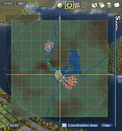
| Face camera to the north
|
|
 |
|
|
|
| Grid |
|
|
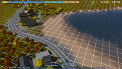
Show 10m grid lines layed to the north, south, east and west on the map.
|
|
 |
|
|
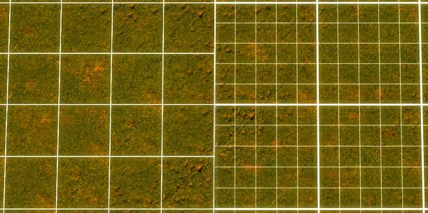
[4m Grid]
If you select the icon again while 10m grid lines are shown, 4m grid will be shown instead of 10.
4m grid has an adjustment feature, which helps to place the buildings / railroad trucks / items along the grid line during the construction.
Note: Only 4m grid supports the adjustment feature. |
|
 |
|
|
| Hide Menu |
|
|
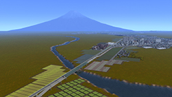
Hide all the menus on game screen
Press ○ button to show menus again
[Mouse / Keyboad Operation]
Move the mouse cursor to the top of screen and press[0] key to unhide menus |
|
 |
|
|
| View Point |
|
|
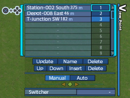
× button and directional button / left click to select the number from list and perform the following operation to save the current camera position.
・Set : Save the current camera position at the number selected from the list.
*If the number has already been saved for another position, a new position will be saved at the number.
・Name : Automatically name the view point based on the information of nearby station or intersection.
*× button and directional button / left click to select the name saved to slot, you can change the name as you like.
・Delete : Delete data of the selected number.
・Up : Switch selected a view point with upper one.
・Down: Switch selected a view point with lower one.
・Insert : Add a row above the selected view point. If the bottom of the list has been set as a view point, you can not select.
・Delete : Delete a row of the selected view point. a lower row will shift up.
・Manual : Move camera manually with operation buttons * Only for mouse
Left click left and right arrow buttons to move camera
Left click and drag ◆ button to change the camera direction while camera position is still locked.
・Auto : Track objects near camera automatically.
・Switcher : Show saved cameras in order. Need to set more than 2 view points. If camera has been moved manually, the switcher setting will be unset.
Only one of "View Point", "Calender Timer", "Height Bar" or "Target Data" can be selected from Side Menu. |
|
 |
|
|
|
| Calender Timer |
|
|
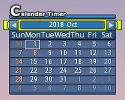
The current date can be checked in the displayed calender.
You can pause the time in a game at 0:00 by selecting the date on the calendar.
Left and Right arrow : Change a selected month
Month Display : Reset the display of the current year/month/day
Date Display : Press × button and directional buttons to select the date. Press × button to set pausing timer on the date.
Only one of "View Point", "Calender Timer", "Height Bar" or "Target Data" can be selected from Side Menu. |
|
 |
|
|
| Height Bar |
|
|
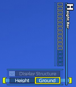
Hide the higher buildings or grounds than the selected height. Lay railroad tracks or construct roads underground or overhead by specifying height.
・Ground : Show the height of the point under the cursor.
・Height : Hide the higher grounds than the set height.
Hover the cursor over the gauge of height bar, press × button and up & down of directional buttons / left click / use scroll wheel to set the height.
・Display Structure : Disable to hide buildings except for ones related to railroad or road.
Only one of "View Point", "Calender Timer", "Height Bar" or "Target Data" can be selected from Side Menu. |
|
 |
|
|
| Target Data |
|
|
This function shows information for a building / vehicle / place which is under the cursor and wind direction and speed (Blue), total electricity demand (Orange), total electricity generation capacity (Yellow).
Only one of "View Point", "Calender Timer", "Height Bar" or "Target Data" can be selected from Side Menu. |
|
 |
|
|
© 2010-2020 ARTDINK. All Rights Reserved.
*Please enable JavaScript in your browser to view all content on this site.
|


