|
||||
|
||||
| Side Menu | ||||
|
||||
| Satellite Display | ||||
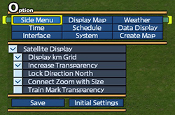
| Show or Hide the satellite. Options of the satellite can be enabled / disabled as well. 【Display km Grid】 View gridlines at 1 kilometer intervals on satellite. If coordination area has been set, the interval will be 320 meters. 【Increase Transparency】 Increase transparency of the satellite. 【Lock Direction North】 Lock the direction in satellite to the north. If this option is enabled, camera can be turned by turning the map. If this is disabled, satellite can be turned by turning the map. 【Connect Zoom with Size】 Satellite will be zoomed in /out based on the change of size. 【Train Mark Transparency】 View only marks of selected trains, buses and trucks on the satellite. |
||||
| © 2010-2020 ARTDINK. All Rights Reserved. *Please enable JavaScript in your browser to view all content on this site. |
||||
